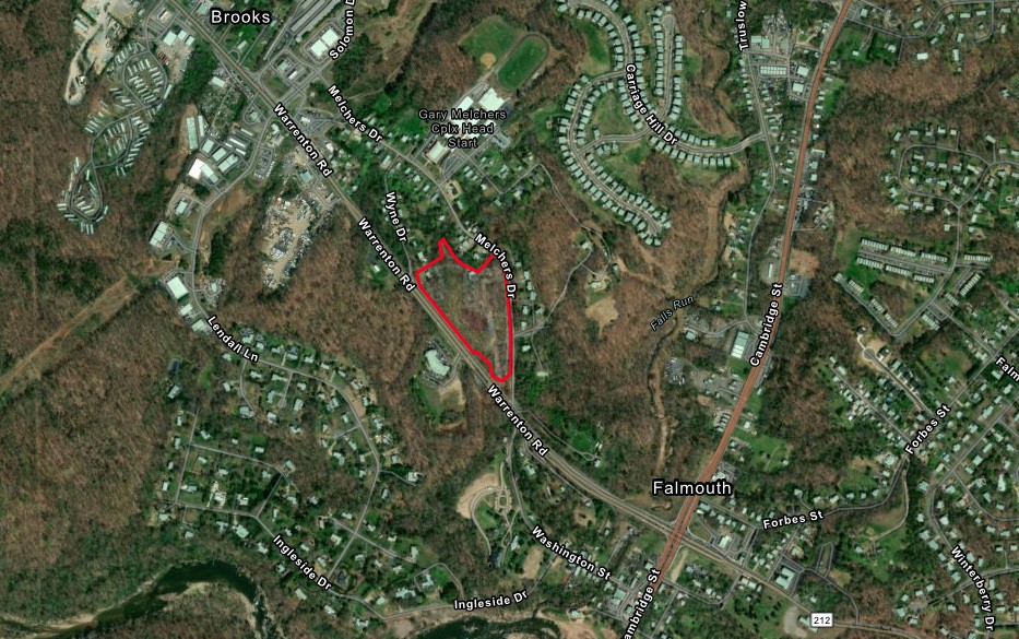
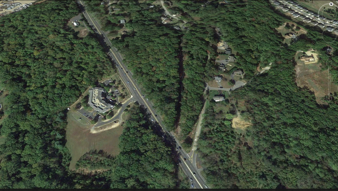
MELCHERS DRIVE
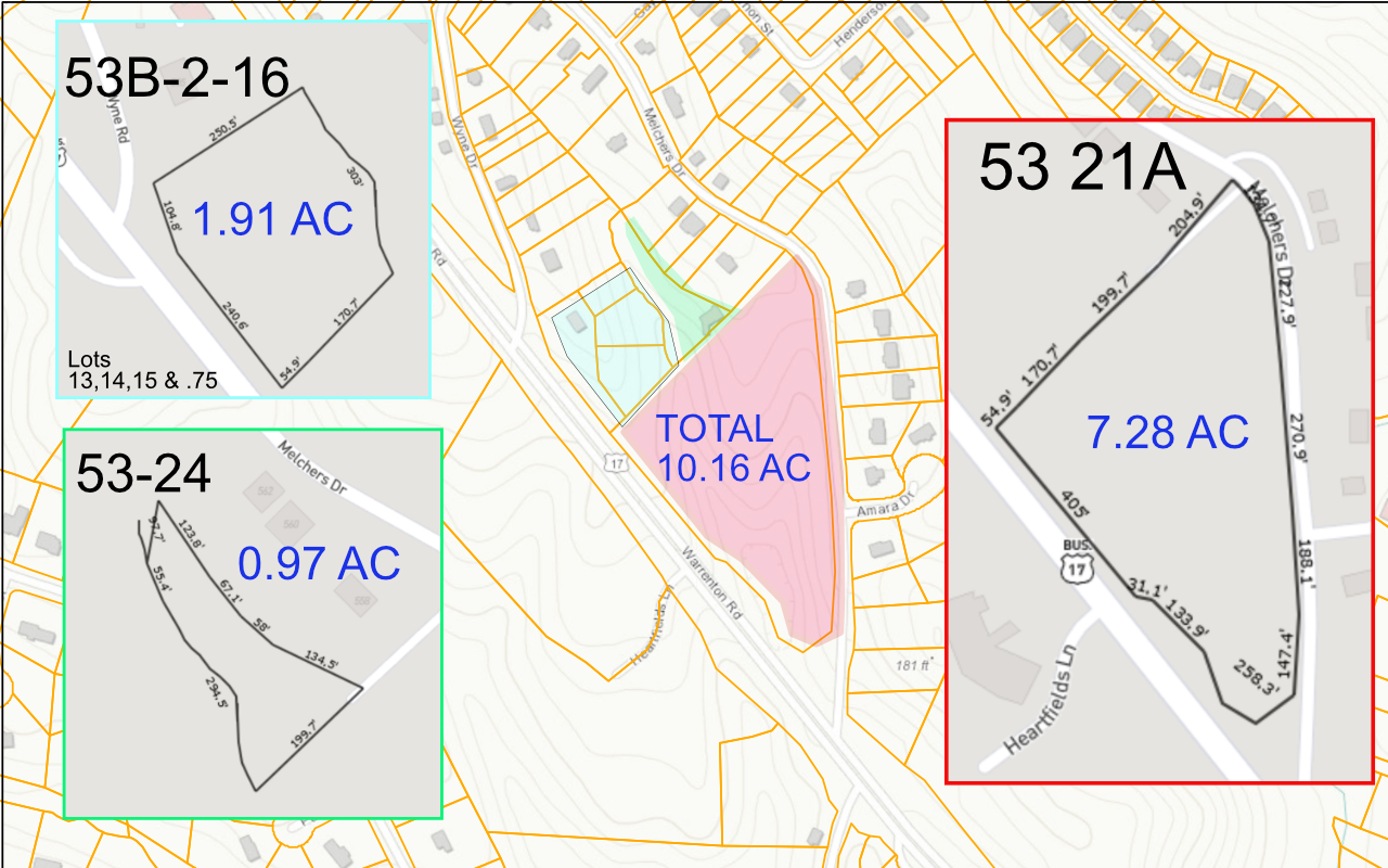
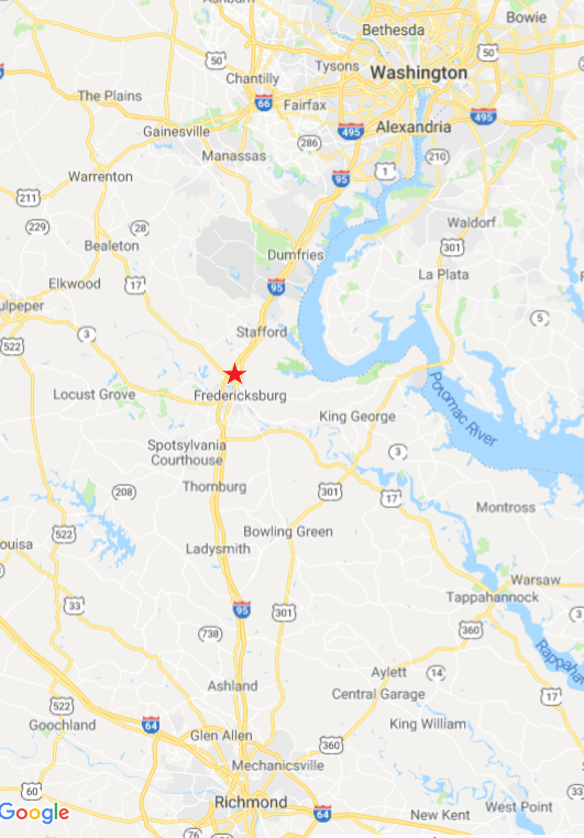
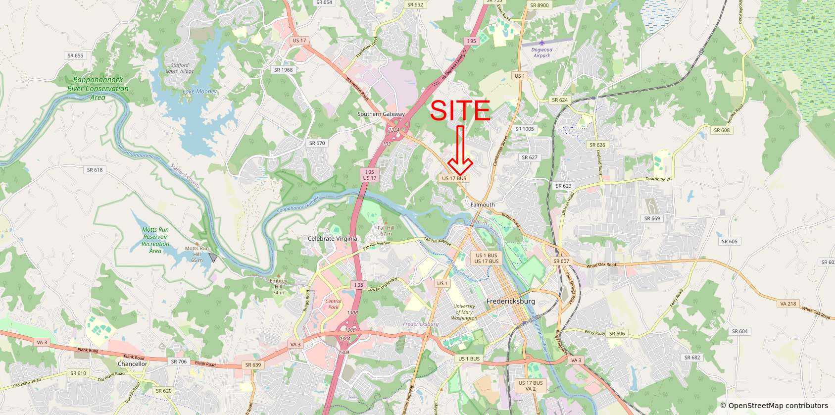
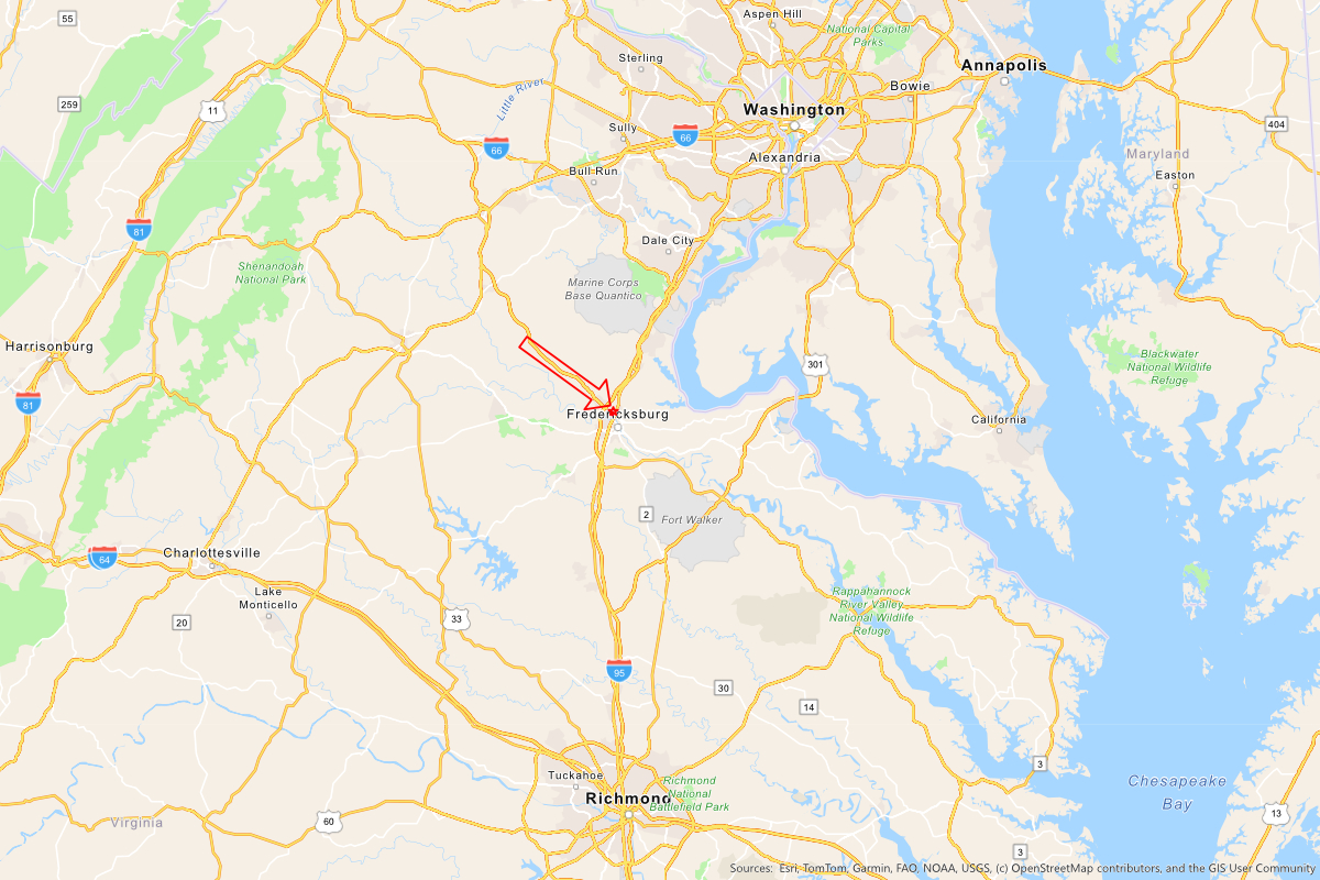
10.15 Acre Commercial Land One mile off 95 on Route 17/ Warrenton Rd. Fredericksburg – Stafford County
$1,700,000.00
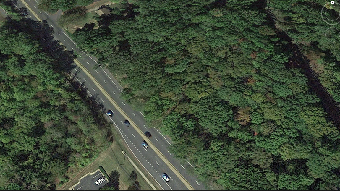
10.15 Acres Facing State Route 17/ Warrenton Rd.
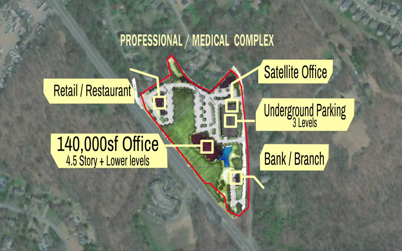
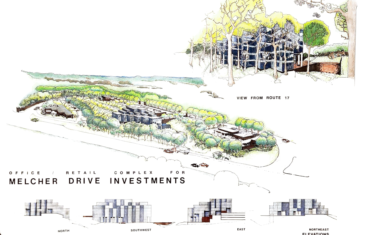
This land has engineered plans drawn for a retail/office complex.
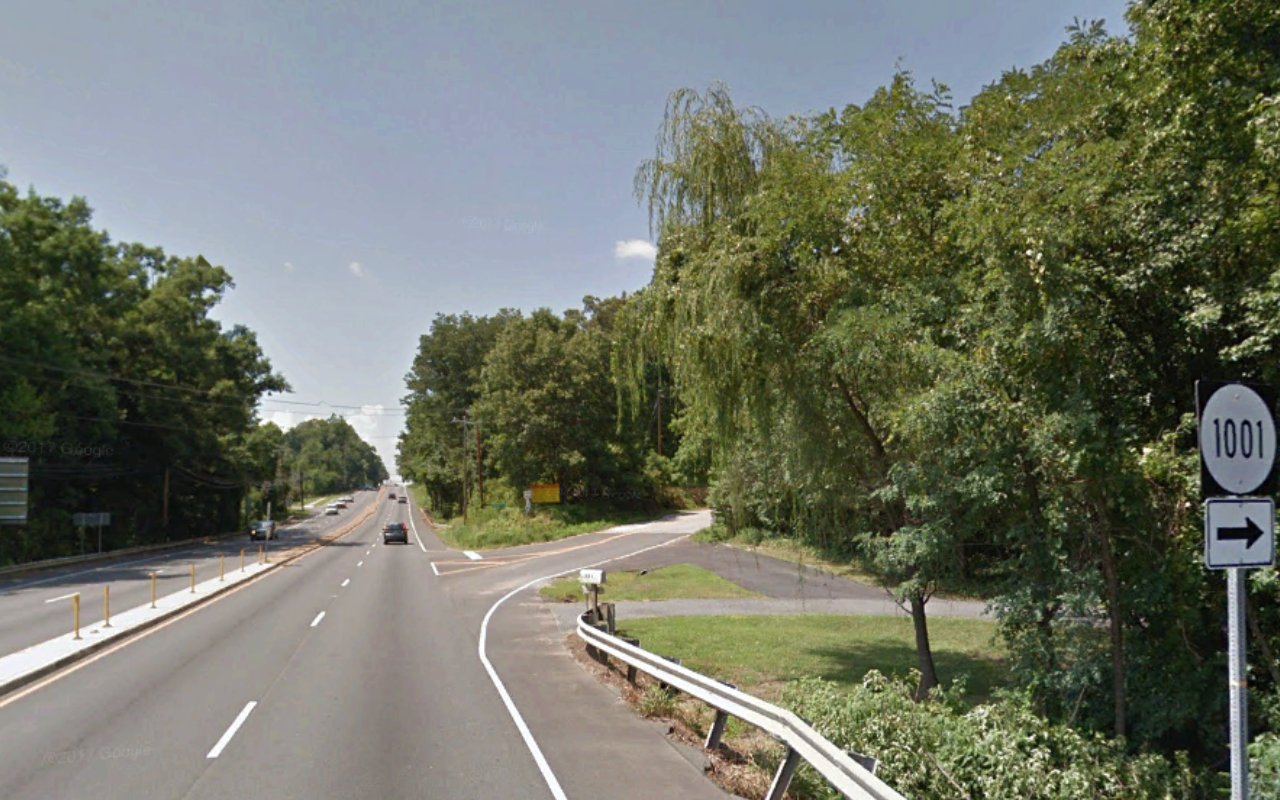
Route 17 is a large corridor to Interstate 95 and Route 1 in South Stafford at the Fredericksburg City border.
The parcels are close to the commuter rail and mere minutes from I-95.
Details
-
Adv Daily Traffic: 34.000
-
Unimproved Land
-
Engineering Study
-
Water Study
-
Commercially Zoned
-
Access to Public Water and Sewer
-
2 residential rental units on site
Location


CONCEPT


Planning & Zoning
Stafford County Zoning
The full ordinance can be found here.
B-3 Office Zoning
B-3 Office.
The purpose of the B-3 district is to provide areas in the county for the location of professional offices and office parks. Such areas should be located as transitional areas between commercial and residential uses.
v(a)
Uses permitted by right:
Bank and lending institution.
Clinic, medical and dental.
Farmers market (in accordance with subsection 28-39(v)).
Flex office.
General office use.
Low intensity commercial retail.
Medical/dental office.
Professional office.
Public facilities/utilities but not including generating facilities, substations, switching stations and wastewater treatment facilities which are permitted as a conditional use permit and not including propane and heating fuel distribution facilities.
Public works excluding wastewater treatment facilities.
Restaurant without drive-through.
School.
School, vocational.
(b)
Conditional use permit:
Child care center.
Drive-through.
Hospital.
Hotel/motel.
Laboratory research and testing facility.
Printing, publishing, engraving.
Public facilities/utilities for generating facilities, substations, switching stations and wastewater treatment facilities (except for the expansion or modification to a wastewater treatment facilities existing prior to October 17, 2006).
Public parking lot.
(c)
Requirements:
(1)
Intensity: Ratio
Maximum floor area ratio ….. 0.65
Maximum floor area ratio with TDR ….. 1.3
Minimum open space ratio ….. 0.30
Minimum open space ratio with TDR ….. 0.15
(2)
Minimum yards: Feet
Front* ….. 40
Side ….. 10
Back ….. 25
(3)
Maximum height (in feet) ….. 65
* Front setback may be reduced. Specified in subsection 28-59(f)(10).
Highway Corridor Overlay Districs
Sec. 28-59. – Highway Corridor Overlay District (HC).
Share Link to sectionPrint sectionDownload (Docx) of sectionsEmail section
(a)
Purpose of the HC. In furtherance of the purposes set forth in Code of Virginia, §§ 15.2-2280, 15.2-2283, 15.2-2284 and 15.2-2285, and in general to protect the health, safety and general welfare of the public by the prevention or reduction of traffic congestion, and distracting visual clutter which may result in danger on the public and private streets, a limitation is hereby placed on certain automobile-oriented, fast service, quick turnover uses and related signage, which generate traffic in such amount and in such manner as to present the possibility of increased danger to the motoring public and other impediments to safe travel. This district is created in recognition of the need to provide suitable and sufficient road systems in the county and the need to protect existing and future highways from unsafe use.
(b)
Establishment of districts. The Highway Corridor Overlay District (HC) shall be designated by the board of supervisors by separate ordinance and will overlay all other zoning districts where it is applied so that any parcel of land lying in a HC shall also lie within one or more other land use districts provided for by this chapter. The regulations and requirements of both the underlying district(s) and the HC shall apply; provided, however, that when the regulations applicable to the HC conflict with the regulations of the underlying district, the more restrictive regulations shall apply.
(c)
District boundaries.
(1)
HC boundaries shall be designated on the official zoning map as ordained by Ordinances O95-57, O96-23 and amended by O98-27, O96-24, O98-30, O01-29, and O01-37 establishing the boundaries of the overlay district, pursuant to article XII, Amendments to Zoning Maps.
(2)
The district boundaries will be described as follows:
a.
Length of the district shall be established by fixing points of beginning and end in the centerline of a street.
b.
Width will be established by designation of the distance on one or both sides from the centerline to which the overlay district shall extend; or, by a description of coterminous property boundaries of lots along such street, or highway; or, by using visible geographic features.
The HC zoning district shall be established and overlay all other zoning districts, except HI districts, on all parcels of land within the below described area:
Beginning at a point at the centerline of Cambridge Street, extending five hundred (500) feet east from the centerline of Cambridge Street at the intersection with the centerline of Truslow Road; thence continuing in a northerly direction parallel to the centerline of Cambridge Street to a point where Cambridge Street becomes Jefferson Davis Highway; thence along Jefferson Davis Highway continuing in a northerly direction parallel to the centerline of Jefferson Davis Highway to a point at the centerline of Courthouse Road; thence continuing in a westerly direction along the centerline of Courthouse Road to five hundred (500) feet west of the centerline of Jefferson Davis Highway; thence continuing in a southerly direction from the centerline of Courthouse Road, parallel to the centerline of Jefferson Davis Highway to a point where Jefferson Davis Highway becomes Cambridge Street; thence continuing in a southerly direction along Cambridge Street to the centerline of Truslow Road; thence, extending along the centerline of Truslow Road to the point of beginning; encompassing all or part of the parcels listed on Attachment A, attached hereto, as shown on the map entitled “Proposed Route 1 Highway Corridor Overlay District” dated December, 2001, made by the Stafford County Department of Planning and Community Development, a copy of which shall be added to and become part of the Official Zoning Map of Stafford County.
(d)
Uses permitted by right. All uses permitted by right in the underlying land use district(s), shall be permitted by right in the HC unless otherwise specifically made a conditional use by this section.
(e)
Conditional uses. In addition to the listed uses requiring a conditional use permit (as listed in Table 3.1) in the underlying district, the following uses shall require a conditional use permit when proposed to be established in a HC:
(1)
Car washes, self-service and automated.
(2)
Funeral chapel, funeral home, or mortuary.
(3)
Convenience stores.
(4)
Theaters, arenas, or auditoriums.
(5)
Recreational enterprise.
(6)
Hotels or motels.
(7)
Hospitals.
(8)
Motor vehicle fuel sales.
(9)
Automobile repair.
(10)
Any uses which include drive-through facilities.
(f)
Development standards. All nonresidential uses shall be subject to the use limitations and development standards set forth in the underlying land use district(s) and, in addition, shall be subject to the following HC limitations:
(1)
Access and internal circulation shall be designed so as not to impede traffic on a public street. To such end, access via the following means will be approved:
a.
By provisions of shared entrances, interparcel connection and travelways, or on-site service drives connecting adjacent properties.
b.
By access from a secondary public street as opposed to the corridor highway.
c.
By the internal streets of a commercial, office, or industrial complex.
Developers of all parcels or lots within the HC shall submit an access and internal circulation plan to the county for approval which addresses access for the project and the surrounding area.
The access plan shall demonstrate the ability to provide adequate access to surrounding properties via cross-easement agreement(s), shared entrances, interparcel connections and travelways, on-site service drives connecting adjacent properties, and/or access by secondary public streets.
(2)
Pedestrian circulation shall be provided for and coordinated with that generated from or using adjacent properties.
a.
The requirement for the provision of pedestrian circulation for the development of any parcels abutted on both sides along its road frontage to undeveloped parcels may, at the option of the county administrator, be satisfied by the execution and recordation of a sidewalk security agreement between the owner of the property and the county administrator to be prepared by the director of planning. The agreement shall provide for payment of one hundred twenty-five (125) percent of the amount of an engineer’s certified cost estimate of the construction of the required sidewalk(s) at the time of permits or by monthly installments during a term not to exceed thirty-six (36) months and shall contain appropriate provisions for acceleration upon the sale or transfer of the property or upon a breach of the terms of the agreement. Payments made pursuant to this section shall also include an administrative fee of one hundred dollars ($100.00) which shall be payable at the time of the execution of the sidewalk security agreement.
b.
The requirement for the provision of pedestrian circulation for the development of any parcels abutted on both sides along its road frontage to undeveloped parcels may, at the option of the planning director (agent) or his designee, be satisfied by a payment in lieu of constructing the required pedestrian circulation. The payment shall be in the amount of an engineer’s certified cost estimate of the construction of the required sidewalk(s) that is deemed to be acceptable by the agent. Such payment shall be made at the time of permits. The payment shall be deposited in an account designated for pedestrian circulation improvements along the corridor highway that serves the property.
(3)
Outdoor storage of goods shall be completely screened from view of the corridor highway. Outdoor storage shall include the parking of company owned and operated vehicles, with the exception of passenger vehicles. Outdoor display areas shall not encroach into any required front yard, with the exception that outdoor display areas may extend fifteen (15) feet from the building front; however, in no case shall outdoor display areas be permitted less than fifteen (15) feet from the street right-of-way.
(4)
Parking areas and driveways shall be paved with concrete, bituminous concrete, or other similar material except for low-impact development sites in accordance with the provisions of chapter 21.5 of this Code where pervious paving blocks and other similar materials may be allowed as approved by the agent. Surface treated parking areas and drives shall be prohibited. Concrete curb and gutter shall be installed around the perimeter of all driveways and parking areas, except that concrete curb without a gutter may be permitted where drainage is designed to flow away from the curb, and asphalt curb may be permitted where the property adjacent to a travel lane is undeveloped. Drainage shall be designed so as to not interfere with pedestrian traffic.
(5)
Where parking is designed to be located in the front yard setback of the corridor highway, a berm shall be utilized within a designated street buffer. Where no berm is proposed within a designated street buffer, whenever possible, parking areas shall be located to the rear or side of the structure(s) or building(s) they are intended to serve.
(6)
Utility lines such as electric, telephone, cable television, or similar lines shall be installed underground. This requirement shall apply to lines serving individual sites as well as to utility lines necessary within the project. All junction and access boxes shall be screened. All utility pad fixtures and meters shall be shown on the site plan. The necessity for utility connections, meter boxes, etc., should be recognized and integrated with the architectural elements of the site plan.
(7)
Loading areas and service entrances shall be oriented and/or screened so as to not be visible from the corridor highway. Service bays shall be oriented so as to not face the corridor highway.
(8)
Dumpster and other waste disposal or storage areas shall be completely screened from the public view by means of a board-on-board fence and/or landscaping, or similar opaque material approved by the zoning administrator.
(9)
Architectural treatment shall be designed so that all building facades of the same building (whether front, side or rear) will consist of similar architectural treatment in terms of materials, quality, appearance, and detail pursuant to the neighborhood design standards plan element of the comprehensive plan. No facade portion of a building constructed of unadorned cinderblock, corrugated metal or sheet metal shall be visible from the corridor highway. Mechanical equipment shall be shielded and screened from public view and designed to be perceived as an integral part of the building.
(10)
Area and bulk regulations in the HC shall be the same as for the underlying land use district(s), except that: The height of buildings or structures within seventy-five (75) feet of the corridor highway shall not exceed two (2) stories or thirty (30) feet, whichever is less; and where parking areas are provided in a manner such that the structure or building is located between the parking area and the corridor highway, the applicable setback requirement may, at the option of the applicant, be reduced to fifty (50) percent of that otherwise required for the underlying district.
(11)
A landscaping and planting plan shall be submitted in conjunction with site plan submittal. Such landscaping and planting plan shall be drawn to scale, including dimensions and distances, and clearly delineate all existing and proposed parking spaces or other vehicle areas, access aisles, driveways, and the location, size, and description of all landscaping materials and areas. Landscaping and planting plans shall be prepared by persons practicing in their area of competence.
All plant materials shall be living and in a healthy condition. Plant materials used in conformance with the provisions of these specifications shall conform to the standards of the most recent edition of the “American Standard for Nursery Stock,” published by the American Association of Nurserymen.
Preservation of existing trees is encouraged to provide continuity, improved buffering ability; pleasing scale and image along the corridor. Any healthy, existing tree on-site may be included for credit towards the requirements of this section.
The owner, or his designee, shall be responsible for the maintenance, repair, and replacement of all landscaping materials as may be required or approved within the scope of these provisions.
(12)
Redevelopment or expansion of structures or uses that were in existence prior to the adoption of the HC district and where the square footage of any addition to a structure shall not be more than the square footage of the primary structure shall be exempt from the provisions of subsections 28-59(f)(5), (6) and (9); provided that such redevelopment shall not result in an increase of outside storage area or display on the undeveloped site.
Sec. 28-38. - Performance regulations.
(a)
Bufferyards. When a bufferyard is required under the provisions of this chapter, compliance with the buffer standards shall relieve the necessity of compliance with the minimum yard provisions, if the buffer requirement is greater than the applicable yard requirement.
(b)
Corner lots. Nonresidential corner lots shall be considered to have two (2) fronts and are subject to front setback requirements for both fronts. Residential corner lots shall be considered to have one front where the front yard shall be determined to be the shortest street facing side. All other street facing sides shall have a yard of twenty-five (25) feet or the minimum front yard requirement, whichever is less.
Landscaping, fences, hedges, berms, and similar features of corner lots shall not impair clear sight distance for the intersection. A clear area from three (3) feet above grade to ten (10) feet above grade shall be maintained at all times.
(c)
Accessory buildings/structures. No accessory building or structure shall be located within ten (10) feet of any property line on any lot greater than one acre; no accessory building or structure shall be located within five (5) feet of any property line on any lot of one acre or less; no accessory building and/or structure, except for walls, fences and signs shall be located in any front yard or street-facing side yard.
No accessory building or structure shall be located within ten (10) feet of any other structure, unless it is attached to the primary structure and does not intrude into any required setbacks. In residential districts of lots less than one acre, no accessory building shall be located closer than five (5) feet to the property line except, on townhouse lots, accessory buildings may be located no closer than three (3) feet to the side property line and be exempt from rear setbacks where the lot abuts a common open area or other easement at least ten (10) feet in width.
Notwithstanding those structures specifically excepted in subsection 28-24(1) or by subsection (d) below, no accessory building or structure shall exceed the height of the primary structure. On townhouse lots, no accessory building and/or structure shall exceed ten (10) feet in height.
All accessory buildings and/or structures, except for fences or walls, on townhouse lots shall be not more than one hundred (100) square feet in size.
All accessory buildings and/or interpretive buildings within the HI district shall be exempt from the preceding conditions listed in this subsection.
(d)
Exceptions to height regulations. The board of supervisors may modify the height requirements otherwise imposed in any district for a specific structure by review and approval of a conditional use permit, pursuant to the provisions of section 28-185.
(e)
Setbacks in approved industrial parks. n/a
(f)
Requirements where street improvements are planned. Where roadway improvement plans are identified in the Comprehensive Plan, or are approved by either the Virginia Department of Transportation or the board of supervisors, for the widening, opening, or relocation of any street or highway within the county, it shall be required that setbacks for any new construction be calculated based on the planned right-of-way area and that the location of improvements be set outside of the planned right-of-way area as provided herein. The planned right-of-way area shall remain free of structures, parking areas, vehicle travel lanes, and monument signs, except for perpendicular utility crossings, perpendicular entrances, and approved landscaping.
(g)
Requirements for outdoor display and storage areas.
(1)
No outdoor display or storage area shall be permitted to obstruct any public access or fire exit to a building. No travel lanes or required parking shall be obstructed.
(2)
Outdoor storage areas shall be screened from all public streets and adjacent properties if the adjacent property does not have outdoor display or storage areas. Outdoor storage areas shall not be permitted in any front yard.
(3)
Outdoor storage of commercial vehicles and associated equipment, where permitted, shall be in the rear or side of principal structures, and shall not be visible from residential districts and public rights-of-way.
(h)
Density requirements. The allocated densities for each respective land use district shall not be exceeded. The maximum net density for all land use districts shall be calculated as follows: Subtract the areas of all wetlands, floodplains and slopes greater than thirty-five (35) percent from the gross area of the site to obtain the net area. Multiply the net area of the site by the allocated density to obtain the maximum net density permitted for the site.
(i)
Exceptions to floor area ratio regulations. The board of supervisors may modify the floor area ratio requirements in any district for a building or structure by review and approval of a conditional use permit, pursuant to the provisions of section 28-185.
(j)
Exceptions to open space ratio. The board of zoning appeals may modify the open space ratio requirements otherwise imposed in any district for a specific use by review and approval of a special exceptions, pursuant to the provisions of section 28-351.
(k)
Setbacks from critical resource protection area (CRPA). Refer to county Code chapter 27B.
(Ord. No. 094-29, § 28-308, 8-9-94; Ord. No. 094-53, 12-6-94; Ord. No. 097-58, 10-7-97; Ord. No. 000-25, 5-16-00; Ord. No. 000-33, 10-3-00; Ord. No. O03-54, 9-16-03; Ord. No. O05-44, 9-20-05; Ord. No. O05-33, 12-13-05; Ord. No. O07-40, 9-4-07; Ord. No. O08-02, 5-6-08; Ord. No. O08-28, 6-3-08; Ord. No. O14-10, 12-16-14; Ord. No. O21-26, 8-17-21)
Parking Ratio Table condensed
| Use Category | Number of Parking Spaces Required Per Gross Floor Area (GFA) | # Loading Spaces Min 12x 25 ft |
| Adult day care center | 1.0 per 4 care recipients | 1 |
| Auditoriums, theatres and other public assembly uses | 1.0 per seat | 1 |
| Broadcasting station | 3.0 per 1,000 gfa | 1 |
| Child care center | 2 per classroom | 1 |
| Commercial retail – low intensity (use not otherwise listed) | 3.0 per 1,000 gfa | 1 |
| Community buildings, lodges, clubs, museums, etc. | 4.0 per 1,000 gfa | 1 |
| Conference facility* | 1.0 per every 4.5 persons permitted max. occupancy | 2 |
| Convenience center | 6.0 per 1,000 gfa | 1 |
| Convention facility* | 1.0 per every 3 persons permitted max. occupancy | 2 |
| Dwelling watchman/caretaker on premises | 2.0 per dwelling | 1 |
| Hospitals | 2.0 per bed plus 1.0 per employee of the largest shift | 2 |
| Hotels and motels | 1.0 per room | 1 |
| Libraries | 3.0 per 1,000 gfa | 1 |
| Lounges, etc.* | 1.0 per 1,000 gfa | 1 |
| Medical and dental clinics | 4.0 per 1,000 gfa | 1 |
| Nonretail, e.g., banks, general office, personal service shops, etc. | 3.0 per 1,000 gfa | 1 |
| Places of worship | 3.0 per 10 seats | 1 |
| Printing, publishing, engraving | 3.0 per 1,000 gfa | 1 |
| Restaurants: Sit-down | 11.0 per 1,000 gfa | 1 |
| Restaurants: Fast-food/drive-in | 11.0 per 1,000 gfa** | 1 |
| Restaurants: With delivery | 11.0 per 1,000 gfa** | 1 |
| Restaurants: Delivery only no seating | 28-102(8) and 28-256(c)(3) for stacking requirements + 1.5 per employee on maximum shift | 1 |
| Schools: Day/nursery schools | 2 per 10 students | 1 |
| Schools: Elementary | 1.5 per 25 students plus 1 bus per 100 students | 1 |
| Schools: Middle | 1.0 per 15 students plus 1 bus per 100 students | 1 |
| Schools: High and prep | 1.0 per 5 students plus 1 bus per 100 students | 1 |
| Schools: Vocational/professional/industrial | 4.0 per 100 s.f. gfa classroom space | 1 |
| Schools: College/university | 2.0 per 100 s.f. gfa classroom space | 1 |
| Schools: Dormitory residence | 1.0 per residence room | 1 per building |
| Schools: Gymnasium | 1.0 per 400 s.f. gfa gymnasium space | 1 per building |
| Office/administration | 1.0 per 300 s.f. gfa office/admin. space | 1 per building |
| Swimming pools | 1.0 per 100 sq. ft. of water surface | 1 |
| Tailor shop | 3.0 per 1,000 gfa | 1 |
| Vehicle fuel sales | 1.0 per pump | 1 |
Full Parking Table: https://library.municode.com/va/stafford_county/codes/code_of_ordinances?nodeId=COCO_CH28ZOOR_ARTVIIPALOROACRE
Targeted Development & Comp Plan
Falmouth Gateway (Warrenton Road East) Targeted Development Area
In total, the Falmouth Gateway TDA is recommended to include 1,650 residential dwelling units, including 750 multi-family, 400 townhouse, and 500 single-family units, and 1,000,000 square feet of business development.
Land Use Concept
Figure 3.15 provides a generalized land use concept plan to guide the future development of the Falmouth Gateway TDA.
The area is traversed by Warrenton Road, a major East-West connector for vehicular traffic, and acts as an important link for residents and other visitors to South Stafford and the City of Fredericksburg. Currently, the area is developed with a mix of aging highway oriented commercial uses. A mix of older and newly developing residential neighborhoods are located on the south side of Warrenton Road.
The position of this TGA on Interstate 95 (I-95) makes it attractive for hotels. The availability of road access and ample services and employment may also make this an attractive residential location. Additionally, historic Falmouth Village is a relatively easy to reach, creating an added attraction.
Design
Architectural standards (i.e., building height, mass, materials, amenities, and signage), minimum and maximum setback requirements, environmentally friendly materials, and other design features should be incorporated into any development, consistent with the Neighborhood Design Standards Plan. A mix of uses following the concepts of a traditional neighborhood design is recommended.
Public Facilities
Getting the residents to and from work and other destinations without creating an undue hardship on them and other residents of Stafford County and the Commonwealth of Virginia will require the provision of adequate transportation facilities (beyond the internal community road network).
The roadway network should be designed and developed to provide a hierarchical system of interconnected streets and recognize the dual purpose and functionality of Warrenton Road (Route 17). A comprehensive access management plan should be developed to mitigate the impact of new development. Furthermore, upgrades to the existing transit facility on Warrenton Road may be necessary to offset increased vehicle volumes on I-95 during peak commute periods, including adding parking spaces to the existing park and ride facility.
It is recommended that this TDA include passive and active recreational uses, plazas and congregational spaces, as well as cultural activity. Dedication of open space to support these activities will be required.
The development of so many new dwelling units will by their nature increase the demand on Stafford County schools. To offset the capital cost of that demand, new schools will need to be constructed within this TDA.
The public facility needs are not limited to the items previously listed. The proposed residential development in the Falmouth Gateway TDA would have an estimated 5,115 residents, creating the need for the following public facilities. These facilities should be provided for within the TDA or in areas outside the TDA within close proximity and within the Urban Services Area.
Parks and Recreation : 61 acres
Fire and Rescue: 0.27 stations
Public Schools Elementary Schools :0.42 schools
Middle Schools: 0.17 schools
High Schools : 0.12 schools
Libraries : 0.20 librarie
The data tables that serve as a basis for these public facility needs are provided in Appendix B of this document.
As previously mentioned in the TDA summary section entitled “Public Infrastructure and Services,” these new infrastructure requirements are the result of the new development, its density and location, and therefore will be the responsibility of the developer or developers of properties in the area.
Consistent with this goal, a proposed zoning change should offset the impacts of the new development. Impacts may be offset by voluntary proffers of such things as cash contributions, land dedication for a public facility, or construction of a public facility, as appropriate. Proffers may also include restrictions on the intensity and type of development. In the case of uses requiring a conditional use permit or special exception, the approving body may impose conditions to offset the impacts of the new development.
Phasing of Development
Near-term:
Falmouth Gateway (Undeveloped Land). Seen as an area where growth should be focused to support the businesses along the corridor. The potential for near-term development on vacant parcels is high. The development that has recently occurred in this corridor has followed the highway commercial development pattern.
Mid-term and Long-term:
Falmouth Gateway (Redevelopment). The area consists of a mix of highway commercial and industrial uses that do not fit in with the long-term vision of the Redevelopment Area plans. Widespread redevelopment of the area will take significant time and effort to achieve. It is suggested that the development phase will extend through the mid- and long-term time horizons.
Summary
Projected New Dwelling Units: 1,650
Projected New Commercial Sq. Footage: 1,000,000
Minimum Facility needs within the limits of the TDA (accounting for a portion of the total facility needs identified to serve the TDA):
Upgrades to Warrenton Road (Route 17) and other roads as shown in Figure 4.2 of the Transportation Plan
Passive and active recreational uses, plazas, and civic spaces
FULL COMP PLAN
Targeted Development Areas Overview
By its name, TDAs emphasize where development will be targeted. Each TDA, by its very location, has a different mix of targeted development that may be residential, mixed-use, commercial (retail), and “industrial”. In general, at least 50 percent of the County’s future residential and business development is recommended in these areas.
TDAs are areas of the County where a potential concentrated urban or higher density suburban development pattern is most appropriate. These areas will support a more intense, pedestrian and transit-oriented form of development, located in close proximity to primary road networks and transportation hubs. The land use recommendations in the TDAs are consistent with Section 15.2-2223.1 of the Code of Virginia pertaining to Urban Development Areas.
Areas with a more urban form of development will allow residents to work, live, shop and play within a relatively small area without fully relying on the automobile. Focus should be on the form of development, incorporating principles of traditional neighborhood design, including, but not limited to, (i) pedestrian-friendly road design, (ii) interconnection of new local streets with existing local streets and roads, (iii) connectivity of road and pedestrian networks, (iv) preservation of natural areas, (v) and mixed-use neighborhoods. Various types of dwellings, community uses and business activities may locate within the same block or within a single building. Town centers may include a mix of retail commercial enterprises on the first floor with residential or office condominium units located on the second and higher-level floors as a preferred development pattern to ensure that residents have the ability to shop and work within walking distance of where they live.
The suburban form of development should provide the same benefits as an urban development, but will have an appearance and form similar to the established suburban communities.
Residential – Commercial Land Use Mix and Phasing
It is expected that residential development within TDAs utilizing urban level densities will include a mix of housing types and a mix of uses (residential and commercial). Such mix of housing types and uses will generally occur on the subject parcel(s). Where such parcel(s) are not of sufficient size, the mix of housing types and/or commercial uses may be sited on adjacent or nearby parcel(s). Unless directly connected to a previously approved multi-use project, the mix of housing types and commercial uses shall be in addition to what is already in place or otherwise already approved but not yet completed. Applicants may work in partnership with other developers to satisfying this expectation. In such cases, the partnership to achieve the mix of housing types and uses shall be identified in a consolidated concept and/or master plan. Additionally, development of the residential uses in a TDA utilizing urban level densities shall be phased contingent/consistent with new commercial development to help offset the impacts.
Residential Density Requirements
A goal of the TDAs, as originally adopted in 2016, has been to accommodate 50 percent of the projected population growth over the 20 year period between 2016 and 2036. This requires the Stafford County Comprehensive Plan creation of one or more TDAs within the Comprehensive Plan that provide for the construction of approximately 10,570 new residential units. This should support over half of the projected 56,900 -person population growth and 18,355 dwelling units over the 20-year planning horizon. This estimate is derived by Weldon Cooper Center estimates of future growth trends. The total dwelling unit growth projected between 2016 and 2036 is derived by dividing the 20-year population growth (56,900) by the average persons per household of 3.1 (from the 2020 Census).
The Plan recommends that 10,570 dwelling units be distributed across the five (5) designated TDAs. Each TDA describes the desired number and types of dwelling units. The Plan recommends a maximum dwelling unit figure by unit-type or the maximum commercial square footage for an individual TDA.
Target densities for development within the TDAs include 12.0 condominiums or apartments, 6.0 townhouses, or 4.0 single-family homes per acre where residential development occurs and a minimum density of 0.4 floor area ratio (FAR) where commercial development occurs. To provide flexibility and allow for variations in individual projects, zoning district standards created for TDAs should incorporate the following density ranges:
- 3 to 6 dwelling units per acre for single-family detached homes,
- 5 to 8 dwelling units per acre for townhomes,
- 11 to 14 dwelling units per acre for condominiums or apartments, and
- 0.4 to 1.0 floor area ratio for commercial development
However, in the Downtown Stafford area of the Courthouse TDA, higher density development is permitted as outlined in the Courthouse TDA section of this chapter.
A variety of single-family detached units are supported in these areas. To achieve these higher densities, smaller lot sizes than typically found are anticipated, particularly when located in mixed-use areas and in close proximity to multi-modal transportation.
TDA Development Promotion and Incentives
In the past five years, development of the TDAs has lagged behind other areas of the County. It has been noted by the development community that the zoning entitlement process in these locations can be more costly, time consuming and has higher risk. To promote the appropriate amount of development in TDAs as recommended in this Plan, without sacrificing the necessary evaluation, efforts should be explored by staff to identify and recommend to the Board of Supervisors and Planning Commission appropriate modifications to the review and approval process. Some of the process improvements may include:
- Pursue the development of Small Area Plans in each of the TDAs to clarify desired development patterns.
- Consider a phased approach to zoning reclassification requests that would minimize risk and provide greater comfort level to potential developers.
- Simplify application requirements – impact assessments and development concept details.
- Establish criteria that may allow for an expedited review process.
- Consider modifying application fees.
- Establish standard development guidelines and impact mitigation criteria. Stafford County Comprehensive Plan Chapter 3: The Land Use Plan 3-23
Locations
To encourage smart growth and reduce the impact of unintended and negative impacts upon I-95 and commute times for Stafford residents, Stafford County has included five (5) TDAs within the comprehensive plan. TDAs provide for concentrated areas of development rather than distributing future development across the USA and Agricultural/Rural areas. The TDAs have been located to minimize encroachment concerns with Marine Corps Base Quantico and the Stafford Regional Airport.
Transfer of Development Rights (TDR)
Furthermore, up to an estimated 1,490 dwelling units could be made possible by the transfer of development rights from properties outside the TDAs as part of the TDR Program. For residential purposes, 1 residential development right in the sending area is equivalent to 1 by-right residential development right in the receiving area. For non-residential purposes, 1 residential development right in the sending area is equivalent to by-right construction of 3,000 square feet of commercial space in the receiving area.
Public Infrastructure and Services The TDAs should include transportation, recreational, public safety, and educational amenities. For example, smaller yards and open spaces within the required dense developments makes the provision of parks and other recreational facilities essential for a healthy lifestyle for the residents. Therefore, the Comprehensive Plan provides for the creation of 575 acres of new public park space in or around the TDAs. It also provides for the creation of an additional large recreational facility similar in size and amenities to Embrey Mill Park.
The types of Parks developed will provide different uses, they may be active or passive in nature. It is not the intent of this Plan to require all of the 575 acres within the limits of the TDAs designated on the Land Use Map. At the same time, the recommended Park land should be within reasonable proximity of the population within each TDA. The following is a list of criteria for the suitable location of parks in relation to each TDA. The types of parks are further described in the Development Control Policy Guidelines for Parks and Recreation Land Requirements.
- Neighborhood Parks/Civic Uses – should be located within the limits of the TDA, be within a 5 to 10 minute walk, or ¼ to ½ mile of the residents within the TDA, and include safe pedestrian and bicycle access.
- Community Parks should be located within 2 miles of the TDA they are intended to serve.
- District Parks shall be located within 15 to 20 minutes driving time of the TDA they are intended to serve.
The requirement for educational facilities will also be driven by such dense development. Traditionally, such facilities are located within the residential areas of the communities. The Comprehensive Plan identifies future need for the construction of three (3) new elementary schools, two (2) new middle schools, and one (1) new High School, which may include a Center for Technical Education. It also provides for the upgrade to one (1) existing fire and rescue facility and construction of four (4) new fire and rescue facilities to meet the increased public safety demands of the planned TDAs as well as a new Stafford Parkway, the extension of Mine Road, and other road upgrades to mitigate the local transportation impacts. These facilities should be sited within or in close proximity to the TDAs.
The above infrastructure improvements are essential components of the more concentrated suburban and traditional neighborhood design recommended in the TDAs and would be required components for approval of rezoning changes within the planned TDAs. Without the upgrades, approval should not be given for rezoning changes because the impact of the development would not be sufficiently mitigated. The infrastructure needs of the TDAs, Suburban and Rural areas relate to Chapter 5 with the Public Facilities Plan and corresponding methodology to calculate anticipated infrastructure needs in Appendix B.
Small Area Plans
To establish the desired land use pattern in each TDA, Small Area Land Use Plans should be developed and adopted as part of the Comprehensive Plan. A Small Area Plan was created for a portion of the Courthouse Area. That Plan provides a finer level of detail, identifying how the recommended land uses and density should be distributed throughout the Courthouse Area in an urban, traditional neighborhood design. The Plan includes a recommended street network.
Site Design
Use of buffering, screening and extensive building setbacks should be limited except when bordering the edge of a TDA. Buildings should not exceed six stories in height. Development in these areas should accommodate the need for affordable housing. Both on-street and off-street parking will be anticipated. In the most densely developed areas, structured parking should be encouraged. Parking structures should be sited and include architectural features to complement surrounding buildings. Development around primary transportation hubs should accommodate commuter parking while respecting the more urban form of development. Future developments should include open common areas or public spaces for residents and/or employees to enjoy leisure time activities. Streets and buildings should be designed to encourage physical and visual interaction at the street level. Street lighting and sidewalks are essential elements to ensure vibrant communities. These areas could also be designated as receiving areas in the County’s transfer of development rights program.
Form-Based Codes
Should an urban, traditional neighborhood design be desired in a given area, the use of Formbased Code may be desired as Stafford County continues its evolution. For the purposes of this 20-year view, Form Based Code will be defined by the following:
Form-based codes address the relationship between building facades and the public realm, the form and mass of buildings in relation to one another, and the scale and types of streets and blocks. The regulations and standards in Form-based codes, presented in both diagrams and words, are keyed to a regulating plan that designates the appropriate form and scale (and therefore, character) of development rather than only distinctions in land-use types. This is in contrast to conventional zoning’s focus on the micromanagement and segregation of land uses, and the control of development intensity through abstract and uncoordinated parameters [e.g., FAR, dwellings per acre, setbacks, parking ratios, traffic levels of service (LOS] to the neglect of an integrated built form. Not to be confused with design guidelines or general statements of policy, Form-based codes are regulatory, not advisory.
Form-based codes are drafted to achieve a community vision based on time-tested forms of urbanism. Ultimately, a Form-based code is a tool; the quality of development outcomes is dependent on the quality and objectives of the community plan that a code implements. The County should make every effort to use Form Based Codes to achieve the desired outcomes for RDAs and the TDAs that are proposed and or contained within this Comprehensive Plan.
Fiscal Balance
The TDAs recommend a fiscally balanced amount of commercial and residential development, as discussed in the prior section of this chapter titled: “Residential – Commercial Land Use Mix and Phasing”. To mitigate any increased tax burdens on current residents, it is recommended that each TDA develop over time in a balanced and phased manner, with adequate commercial development to offset the demands on community facilities and infrastructure that residential development brings. This can be accomplished by ensuring appropriate phasing of larger mixeduse projects and tracking the amount and type of growth in each TDA on a regular basis.
Airport Impacts
Two of the TDAs (Courthouse and Central Stafford Business Area) are in the vicinity of the flight patterns for to the Stafford Regional Airport and its aircraft operations. An Airport Compatible Land Use Plan has been developed which recommends appropriate land uses and development standards in relation to different air traffic pattern areas. To ensure the safety of people and property on the ground and aircraft flying overhead, and the long-term viability of the Airport, any development proposals in these TDAs should be in conformance with the recommendations of the Airport Compatible Land Use Plan.
Specific TDA Locations
The following pages describe the five (5) designated TDAs.
Urban Services Area Urban Services Areas (USAs)
Urban Services Area Urban Services Areas (USAs) are areas designated within the County where more compact development patterns are recommended. Provision of government and community services and facilities will be focused in these areas. Such services will include public sewer and water utilities, location of schools and other public and community buildings as well as provision of transit services. Improvements to the utility system, road networks, pedestrian accommodations, street lights and community facilities may be required to support the land development in these areas.
The area will be comprised of the following land use designations:
• Targeted Development Areas (TDAs),
• Suburban Areas, and
• Business and Industry Areas.
TDA Development Summary
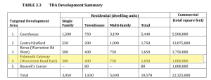
The Development Summary calls for $1,650 Residential Units and 1,000,000 square feet of commercial space.
STAFFORD COUNTY VIRGINIA


Meekins & Associates, INC
——Locations——

DISCLOSURE OF OWNERSHIP INTEREST:
Rudy B. Meekins or any entity in which he has an ownership interest has an ownership interest in any and all properties listed .